The weather warnings increase the safety of the population
The Finnish Meteorological Institute monitors the weather in Finland and elsewhere in the world round the clock. Depending on the situation, it issues warnings on dangerous or hazardous phenomena in Finland.

Online features of the warning service
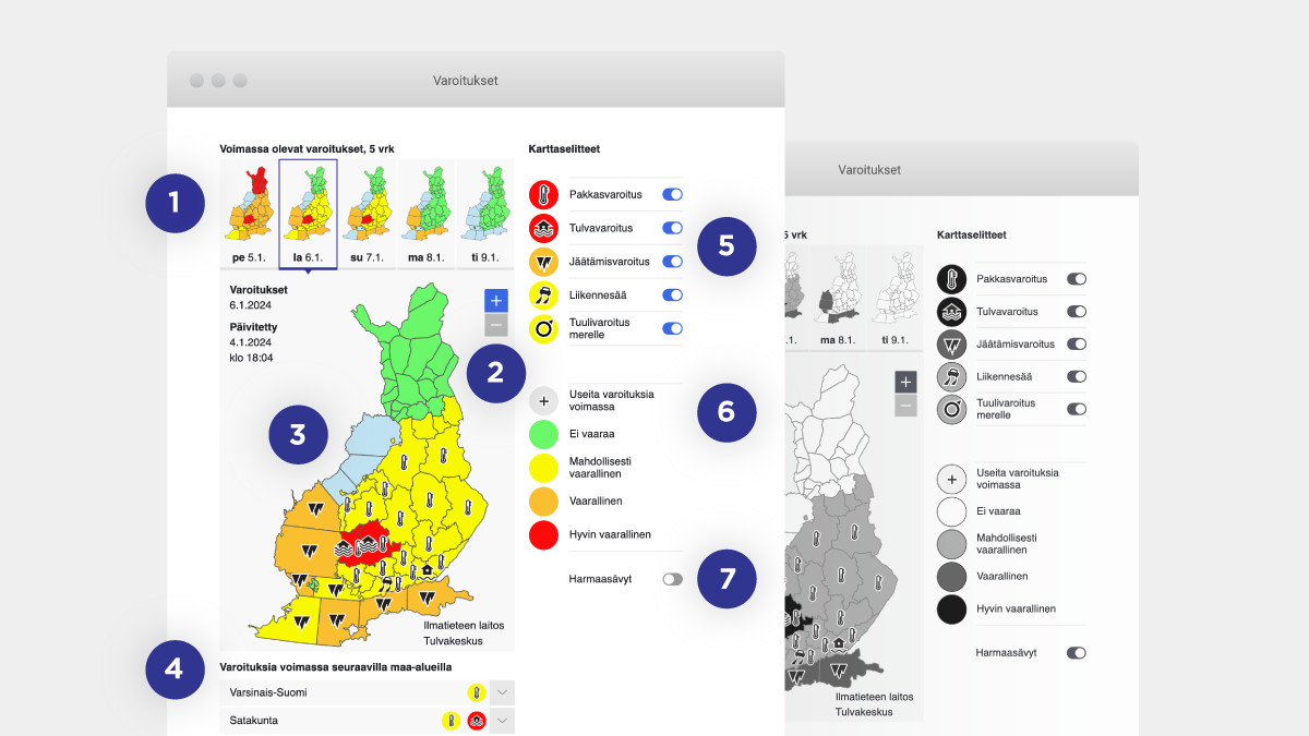
The user can select a day of their choice from the maps at the top of the page. The small pictures give users a quick view of the general warning status for coming days.
The user can also zoom in or out on the map.
By clicking on top of the map, the user will receive more information on the periods for which warnings are in effect.
The user can read local warnings and warning descriptions by opening the text boxes situated below the map.
When there are numerous warning types in effect at the same time, the user can hide the warnings of their choice and then return them to view by clicking on the sliders.
A description of the colours and symbols used for different awareness levels.
You can change the view to grayscale from the slider.
The number of features in use depends on the size of the user's device. Smaller devices offer fewer features.
The severity of the warning is indicated by the colour
The severity of the awareness level is shown on the map by means of a three-colour code system. When more than one warning is in force, it is impossible to fit all types of warning into small regions or sea areas. If the warnings do not all fit in the picture, the map will show the strongest warnings and a +symbol next to them.
Awareness level colours:
green - no major danger
yellow - dangerous weather may occur. You are advised to take the weather conditions into account when you are exposed to weather. You should also keep an eye on the weather and avoid risks.
orange - dangerous weather. The weather may cause injuries and material damage. You should avoid risks that may be caused by the weather. You are advised to keep an eye on the weather on a regular basis and follow the instructions issued by the authorities.
red - very dangerous weather. Injuries and material damage can be expected over a wide area. You should keep a constant eye on the weather and the awareness level. You should also follow the instructions issued by the authorities and be prepared for exceptional measures. The red colour appears on the warning map very rarely.
All warnings has not all warnings levels.
Warnings are issued separately for each day of the week. For example, on Monday, warnings will be issued for Monday, Tuesday, Wednesday, Thursday and Friday. They will indicate the worst situation during that day, such as the strongest wind. The warning threshold is higher in warnings for 2–5 days, and all warnings are not given for periods longer than 24 hours.
Division into regions in weather warnings
Counties are used in warnings and municipalities in the North, but it is possible to use so-called free regional division.
Explore the regional division.
About updates to the warnings
The warnings are normally updated every 3 hours. If necessary, the warnings are also updated at other times. The warning map on the FMI website is kept up to date and it shows all warnings. Other media (television, radio, other websites) may not show all the warnings and warning levels and those shown are not necessarily up to date.
Check the warnings currently in effect in Finland's land and sea areas.
20.6.2024
