Floods in Ostrobothnia monitored using satellite imagery

The Finnish Meteorological Institute has developed methods that can be used in the monitoring of floods. The methods have proved their effectiveness when the Finnish Meteorological Institute, together with the Finnish Environment Institute (SYKE) and the Centre for Economic Development, Transport and the Environment for Northern Ostrobothnia, has used the images to analyse the extent and depth of floods in the Pudasjärvi area. "Tulvakeskus (Flood Centre), a joint venture between SYKE and the Finnish Meteorological Institute, has used the images to form a picture of the situation. The images have enabled us to issue more specific forecasts and warnings on the flood situation," says Jyri Heilimo, Head of Group at the Finnish Meteorological Institute.
The Finnish Meteorological Institute receives images taken by the COSMO-SkyMed SAR satellites in the National Satellite Data Centre operating in the Arctic Research Centre in Sodankylä. The Satellite Data Centre also functions as the national archiving and distribution centre for data from the Copernicus Sentinel satellites, offering, among other things, satellite data processing services. This information can be utilised in the surveying of the environment, such as in monitoring the snow cover and sea ice of the Arctic region, in measuring the quality of water in the Baltic Sea and in the remote mapping of forests.
Satellites provide an broad situation picture in a small amount of time
Satellite imaging has many advantages compared to other available monitoring methods. "Most importantly, satellite imagery can cover wider areas, which allows for faster charting of flood areas. By using imagery from Synthetic-Aperture Radar (SAR) satellites, it is possible to make observations irrespective of weather conditions, cloudiness and lighting," Heilimo specifies.
The traditional methods used in assessing of the extent of floods have been aeroplanes and aerial photography. Aerial photography provides individual photographs from a relatively small area. The straightening and combining of photos taken from an aeroplane takes a lot of time. Moreover, aerial photography is often impeded by visibility problems caused by factors such as rain and cloud height, which can prevent the operation of planes altogether.
Further information:
Research and development of satellite-based services: Jyri Heilimo, Head of Group, tel. +358 50 568 0802, jyri.heilimo@fmi.fiJuval Cohen, Researcher, juval.cohen@fmi.fiNational Satellite Data Centre in Sodankylä: Timo Ryyppö, Head of Group, tel. +358 40 592 1210, timo.ryyppo@fmi.fi
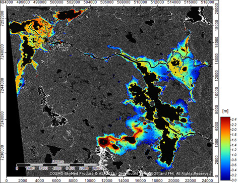
In the image, the extent of the floods and the depth of flood water in the Pudasjärvi and Jongunjärvi areas are presented on top of a SAR image taken from a COSMO-SkyMed satellite. In addition to imagery from the COSMO-SkyMed satellite, images from the Sentinel-1 satellite are also utilised in the flood analysis.
