Finnish researchers made history: The amount of snow in the Northern Hemisphere can now be reliably estimated

The amount of snow and the changes in it are determined by satellite observations and measurements made from the ground. In the past, estimates of the amount of snow in the northern latitudes have varied so much that it has not been possible to obtain a coherent and reliable overall picture of the amount of snow. Researchers at the Finnish Meteorological Institute developed a method to reduce the error margins of various observations.
"The method can be used to combine different observations and it provides more accurate information about the amount of snow than ever before. The previous considerable uncertainty of 33% in the amount of snow has decreased to 7.4%," said Jouni Pulliainen, the main contributor to the article and Research Professor at the Finnish Meteorological Institute.
The amount of snow cover and its changes affect the climate system and freshwater reserves. More detailed data will enable a better assessment of the role of seasonal snow in the carbon dioxide and methane cycles and water resources. The data can also be used to improve the quality of weather forecasts and provide more accurate information on flood risks. In addition, a more accurate historical time series can be used to analyse and develop the reliability of climate models.
The snow mass has remained the same, but the extent of snow cover has decreased
The researchers found that there has been little reduction in snow mass over the 40 years in the northern hemisphere when looking at the annual maximum amount of snow at the turn of February-March.
However, the extent of the snow cover has decreased significantly over the same period, especially in late spring. The change in the extent of snow cover is visible both on the entire northern hemisphere and in the Arctic.
"In the past, estimates of global and regional snowfall trends have only been indicative. The results show that the amount of rainfall has increased in the northern regions, especially in the northern parts of Asia," Jouni Pulliainen said.
In northern areas, where rainfall generally turns to snow in winter, the snow mass has remained the same or even increased. In the southern parts, where in winter rainfall comes down as water rather than snow, both the extent of the snow cover and the snow mass have decreased.
This winter there is more snow in the north than average
This winter, the extent of snow cover has been significantly lower than average, especially in Europe. In Europe, the snow line has been hundreds, in some places even thousands of kilometres north of normal. On the other hand, in the northernmost parts of Europe and Eurasia, there has been significantly more snow than average.
In North America, the amount of snow has also been higher than average in the northern latitudes. In the early winter, there were numerous large snowstorms that brought a large amount of snow to the area at once.
"The snow line across the globe has been more northern than normal this winter, while in the northern latitudes there is much more snow in many places than in the average years," said Kari Luojus, Head of Group at the Finnish Meteorological Institute and co-author of the Nature article.
Further information:
Research Professor Jouni Pulliainen, Finnish Meteorological Institute, tel. +358 29 539 4701, jouni.pulliainen@fmi.fi
Head of Group, D.Sc. (Tech.) Kari Luojus, Finnish Meteorological Institute, tel. +358 40 505 8417, kari.luojus@fmi.fi
The study is available on Nature website.
Reference: Pulliainen, J., Luojus, K., Derksen, C. et al. Patterns and trends of Northern Hemisphere snow mass from 1980 to 2018. Nature 581, 294–298 (2020). https://doi.org/10.1038/s41586-020-2258-0
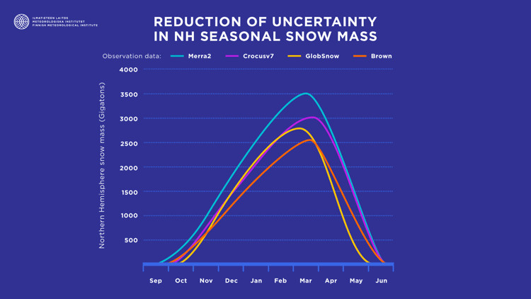
Using a method developed by researchers at the Finnish Meteorological Institute, various snow observations can be combined. The method reduces the error margins of the observations from 33% to 7%. Finnish Meteorological Institute.
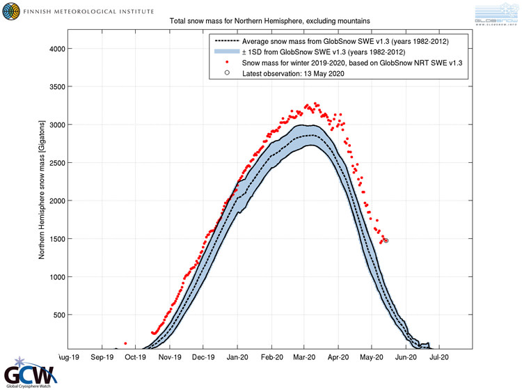
Snow mass in the Northern Hemisphere in gigatonnes. The amount of snow this winter is shown in red, the most recent observation is from 13 May 2020. The average snow mass from 1982 to 2012 is shown in the chart with a black dashed line. Data from satellite observations and ground measurements. Finnish Meteorological Institute and WMO Global Cryosphere Watch.
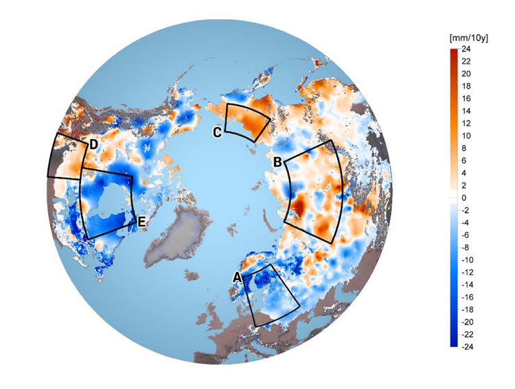
Changes in snow mass between 1980 and 2018. In areas A-E, large regional changes in the amount of snow are observed. In the blue areas (A, E) the snow mass has decreased, in the red areas (B, C, D) the snow mass has increased. The scale is the change in the water value of snow in millimetres per 10 years (the water value indicates how high a column of water the snow corresponds to when melted). Finnish Meteorological Institute, modified from the chart presented in the Nature article.
