News19.10.2021
Artificial Intelligence helps to measure sea ice concentration at the Baltic Sea even more accurately from satellite images
The Finnish Meteorological Institute has developed a convolutional neural network algorithm that can measure ice concentration by using images from radar satellites. The new method is able to identify areas covered in sea ice in satellite images more accurately than before.

Photo: Heidi Pettersson
Sea ice concentration (SIC) indicates where sea ice is located and how large an area it covers locally. Three variants of the algorithm were tested in the research, out of which the SIC-2 method gave the best results.
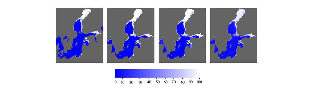
FMI’s Ice Service’s map on sea ice concentration on the left; sea ice concentration on the Baltic Sea according to the three researched methods on 9 April 2019. The method with the best comparative results, SIC-2, is on the right. In the image, ice concentration is displayed in percentages, i.e. 0 = open water and 100 = only ice.
More information:
Senior Scientist Juha Karvonen, Finnish Meteorological Institute, tel. 050 364 3888, juha.karvonen@fmi.fi
Group Leader Marko Mäkynen, Polar Meteorology and Climatology, Finnish Meteorological Institute, marko.makynen@fmi.fi
Juha Karvonen, Baltic Sea Ice Concentration Estimation From C-Band Dual-Polarized SAR Imagery by Image Segmentation and Convolutional Neural Networks, IEEE Transactions on Geoscience and Remote Sensing (Early Access), DOI: 10.1109/TGRS.2021.3097885, 2021.
