Why is there currently so little snow in Lapland?

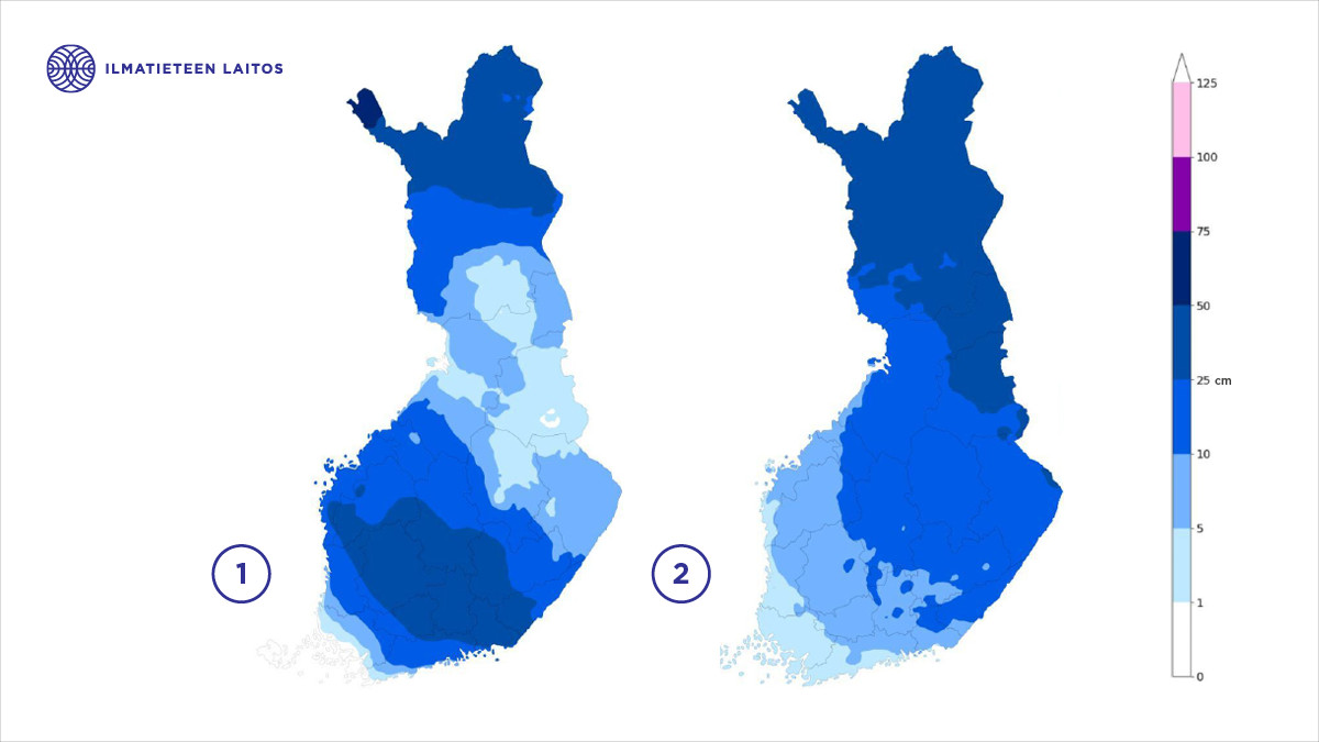
In Southern Lapland, some weather observation stations currently report snow depths of less than ten centimeters. For example, at Kemijärvi Airport, the snow depth on December 17 at noon was only five centimeters. These snow depths are exceptionally low for the season, occurring less than once every 30 years on average.
Snow cover is also below normal across much of Central Lapland. In Sodankylä, for instance, the snow depth is approximately 20 centimeters, which is 10–15 centimeters less than usual for this time of year. The situation is better in Northern Lapland, where snow cover is slightly below average only in some areas.
By comparison, in mid-December last year, Southern and Central Lapland had normal or slightly above-average snow depths. Snow cover ranged generally between 25 centimeters and half a meter.
The last time snow depths were this low was around 20 years ago
The last time Southern Lapland had so little snow was in 2006 when several Finnish Meteorological Institute observation stations reported no snow cover at mid-December. However, additional snow fell on December 15 and 16 of that year.
In Central Lapland, low snow depths at mid-December were especially notable in 1989, when snow cover in Western Lapland, around the Pello area, was approximately five centimeters.
Similarly, in 2000 and 2003, Southern Lapland had less than five centimeters of snow in some places by mid-December, and in Central Lapland, snow depths were generally under 20 centimeters.
December has been drier than usual
This year, November in Southern and Central Lapland was mild and had little precipitation. During the first half of the month, some areas in Eastern Lapland received only a couple of millimeters of precipitation, while the Rovaniemi region and Southwestern Lapland had around ten millimeters, part of which fell as rain.
A mild period lasting several days with westerly and southwesterly winds occurred in early November. By its conclusion on November 9, many observation stations in Lapland reported snow depths of zero centimeters. The snow situation improved slightly on November 21, when storm Jari brought about five centimeters of snow to Southern and Central Lapland.
In late November, there was one more significant frontal precipitation system that brought part of its precipitation as snow and part as rain to Lapland, which again limited snow cover growth. As a result, December began with generally low snow depths across Lapland, except in Northern Lapland.
So far in December, precipitation has been below average in Southern and Central Lapland. This is largely due to natural weather variability and two high pressure systems bringing mostly dry and cold weather in December. Snow accumulation has not gained much momentum in December either.

Snow affects tourism, nature, and people
Low snow cover has various impacts in Lapland. Especially, at the beginning of winter, it negatively affects one of Lapland's most important industries: tourism. For instance, ski resorts face higher costs when there is insufficient natural snow for ski tracks and slopes.
Sparse snow cover also affects animals and plants in many ways. For some people, low snow cover in early winter may exacerbate symptoms of seasonal affective disorder, such as fatigue, low mood, and lack of motivation.
Lapland is warming faster than the rest of Finland due to climate change.
Lapland is warming faster than the rest of Finland due to climate change. It is therefore not surprising that, especially in November, snow cover in southern Lapland remains limited in some years. This is partly because precipitation increasingly falls as rain and partly due to more frequent mild weather periods.
When we combine a warming climate with Finland's typical high variability in weather and the fact that more than half of winter is still ahead, we gain at least a moderate understanding of why Southern and Central Lapland currently have so little snow. As I write this, weather forecasts for the end of this week and Christmas week show signs of at least two low-pressure systems, which will likely increase the snow depths.
Petteri Pyykkö
Meteorologist, Finnish Meteorological Institute
