
History of the Ice Service
In wintertime, ice makes navigation in the Baltic Sea difficult. The Finnish Meteorological Institute's Ice Service provides information on the daily ice condition, e.g., on an ice chart and as an ice report. The information about the ice condition is used primarily by winter navigation, but also by scientists and citizens, for example. In severe winters, all the countries around the Baltic Sea have to use icebreakers to keep their ports open. Even in mild winters, icebreakers are needed, at least in the Bay of Bothnia.
In Finland, the natural isolation by the ice during the winter used to slow down the growth and economic prosperity of foreign trade. Nevertheless, the post was transported between Eckerö in Åland and Stockholm even in wintertime, so Finland was not totally isolated. In addition, ice roads allowed for small-scale trade with neighbouring countries. During severe ice winters, a permanent ice cover was formed in the Quark so that it was possible to travel to Sweden by horses and cars. Nowadays this is not possible because the ships keep the ice field in the Quark broken.
19th century
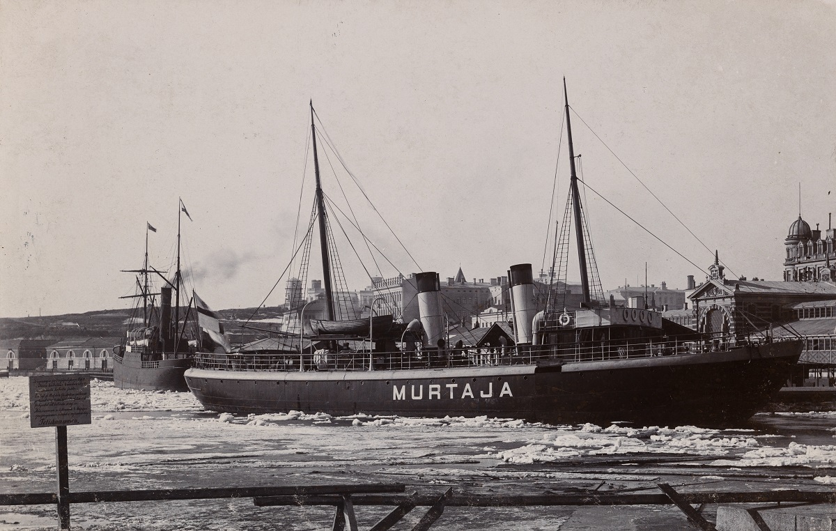
The interruption of maritime connections every winter was a major economic disadvantage. In the middle of the 19th century a possibility of continuing shipping over the winter across the Baltic Sea was investigated. As a result, a regular connection from Hanko to Stockholm began in the winter of 1878. In 1890, the Finnish state acquired the first icebreaker in Finland. The icebreaker ‘Murtaja’ that was built in Sweden secured Finland’s year-round trade via Hanko to Central Europe and England. As a result, the ice conditions in Hanko and the northern Baltic Sea became of increasing interest.
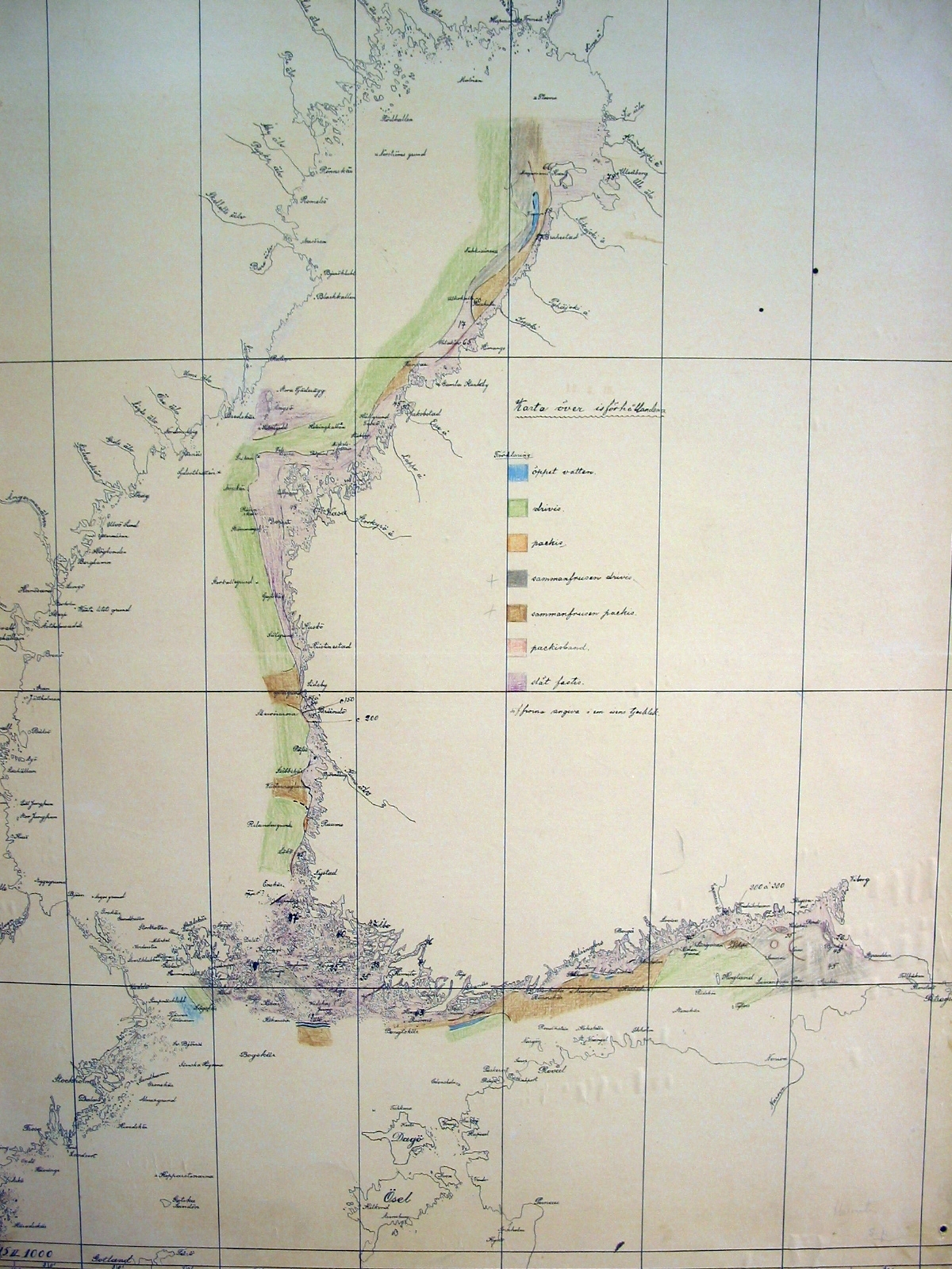
At the very end of the 19th century, the ice observation network was made operational. Ice charts were drawn at the Hanko lighthouse, Bogskär, Utö, Russarö, Jussarö, Porkkala, Harmaja and Söderskär. The work was supervised by the Finnish Society of Sciences and Letters and carried out by the Finnish Meteorological Institute “outside its actual work”.
Early 20th century
Initially, data on the ice situation were collected with a delay of about a month, as the work was carried out “outside the actual work”. Some of the ice data didn´t arrive before summer. The outbreak of World War I changed the situation. The Imperial Navy quickly needed reliable ice data for its strategic plans. Merchant ships also needed better and more up-to-date sea ice information during the war. The Imperial Navy ordered the Finnish Society of Science and letters to make charts of the ice condition on a weekly basis. The Finnish Society of Science and letters began to renew its observation routines, and since 12 March 1915, ice charts were drawn weekly.
On the 7th of January 1927, the ice reports started to be read on the radio. In the same year, from the first of March, merchant vessels were required to keep a special ice logbook when sailing in ice-covered sea areas. In the winter of 1932, icebreakers began sending ice data regularly twice a day.
In 1934, the Finnish Institute of Marine Research entered into an agreement with the Navy and the Coast Guard for regular flight observations, mainly in the Gulf of Finland. In the 1940s, flight observations were already a regular help for winter navigation. Later, the airplanes were replaced by helicopters operated from the icebreakers. They were dropped out in the beginning of 20th century when radar satellite imagery became more common.
Late 20th century
Satellite imagery began to be available to help with ice observation work in 1967. The following winter, the Ice service got the images already a couple of hours after it was taken. Flight observations, satellite images and the evolving icebreaker fleet enabled that in the winter of 1971–72 all of Finland's official winter ports were open throughout the winter and the year-round merchant shipping began. Also winter navigation suitable ship types became more common. Although Finland is like an island in terms of connections, winter and ice no longer prevent shipping to and from Finland.
Nowadays
The ice chart is drawn daily during the winter with a charting program. The ice report is also written daily and e.g. read on the radio. The most important source of information are the radar satellite images that Ice service receives more than a thousand per year. However, also other data sources, like manual ice observations, for example, are used.
Although winters are milder due to climate change, at least some of Finland's ports freeze every year. Still, the weakest ships will not be able to navigate in the ice and even the stronger ones may need help from the icebreakers on their way through the ice. In Finland, winter navigation is controlled by the Finnish Transport Infrastructure Agency, which e.g. determine which ships are being assisted by icebreakers. In practice, the ice class of the assisted vessel must be adequate. Arctia Oy is responsible for the icebreaking, and the icebreakers keep the fairways open and assist the ships to and from the ports. Information about the current ice condition guides e.g. their activities.
18.3.2022