
Satellites provide information about snow cover in the northern hemisphere
The Finnish Meteorological Institute FMI produces daily snow cover maps based on satellite observations. The total mass of snow in the northern hemisphere is at its maximum (statistics 1981-2010) after mid-March. However, the observation time series reveals that the total mass of snow is decreasing – although there are big regional differences. Similarly, the observations indicate that, on average, snowmelt has started to take place earlier.
The area covered in snow is observed with the help of optical devices. However, cloud cover and poor lighting conditions affect the findings in the optical range in winter, especially in northern areas. Optical devices do not directly indicate values such as snow depth or the snow water equivalent, either. The snow water equivalent defines the amount of fresh water in snow, which is essential information, for example, when hydrological forecasts are drawn up. The snow water equivalent also defines the total mass of snow and, because of the strong insulating effect of snow, the total mass is one of the deciding factors when determining the global energy balance (transition of thermal energy between the earth's surface and the atmosphere). Conclusions about the effects of climate change in different areas can therefore be made from temporal and spatial changes in the snow mass.
The snow water equivalent is measured by observing the changes in the natural microwave radiation of the earth's surface. Satellite observations of the so-called brightness temperature of the earth's surface at different microwave frequencies are available for almost the entire globe starting from 1978. The snow water equivalent and, for instance, the point of time when the snowmelt started can be interpreted from the observations by using the method developed at the FMI. Available surface observations of snow depth are used to support the microwave observations to make the satellite observations more accurate.
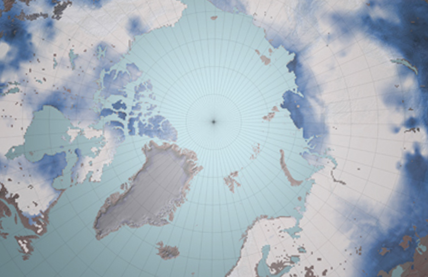
The image shows a presentation of the snow water equivalent in the northern hemisphere in March 2010, calculated using the FMI's method. The satellite observations used are brightness temperature observations from the earth's surface made by the SSMIS microwave radiometer (Special Sensor Microwave Imager Sounder) which is part of the U.S. Air Force weather satellite programme (DMSP, Defence Meteorological Satellite Program). The observation is converted into the snow water equivalent with the help of a physical model that describes the attenuation of microwave radiation at different frequencies due to snow cover and, for example, vegetation. The snow depth observations made by the international network of weather stations are used to calibrate the model to local conditions.
More information:
Kari Luojus, kari.luojus@fmi.fiJouni Pulliainen, jouni.pulliainen@fmi.fiJuha Lemmetyinen, juha.lemmetyinen@fmi.fi
Lisätietoja lumen vesiarvosta: www.globsnow.info